
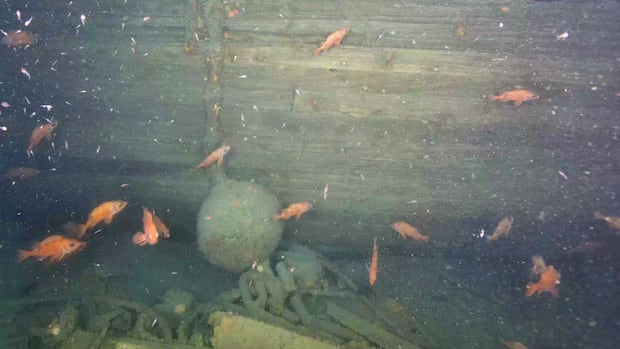
An exploration mission delving nearly 400 meters beneath the Labrador Sea has unveiled the initial visuals of Quest, the vessel that transported renowned Antarctic adventurer Sir Ernest Shackleton on his ultimate journey. The Royal Canadian Geographical Society (RCGS) dispatched a remotely operated vehicle (ROV) to photograph the sunken ship, which rests off the Labrador coast since 1962.
CBC News accompanied the research vessel Atlantis, enjoying exclusive coverage of the expedition’s revealing of the ship’s stern entangled in fishing lines. David Mearns, co-chief scientist of the expedition and an experienced shipwreck locator with 29 discoveries, expressed concern over the damage caused by the nets on Quest, discovered by the RCGS using side-scan sonar two years ago.
The expedition, the largest ever undertaken by the society, carried a multimillion-dollar price tag. It involved a partnership between RCGS and the Massachusetts-based Woods Hole Oceanographic Institution, utilizing their vessel and submersible to explore two shipwrecks in the Labrador Sea. John Geiger, RCGS CEO and expedition leader, made the first dive aboard the submersible Alvin to the wreck, describing the emotional experience of encountering the ship’s bow emerging from the darkness.
Originally acquired by Shackleton for Northern Canadian exploration, Quest pivoted to Antarctic exploration due to lack of Canadian government support. Shackleton passed away from a heart attack onboard near South Georgia in 1922. The vessel was later repurposed as a minesweeper during World War II and then for seal hunting by a Norwegian company. It sank in 1962 after ice crushed the hull, resulting in the loss of its cargo of seal pelts.
Despite the name and registration not being visible on the wreck, research director Antoine Normandin confirmed its identity as Quest based on distinctive features. The expedition aims to create a digital twin of the wreck through 3D imaging technology, despite challenges posed by fishing nets obscuring parts of the ship. The Hawke Channel, where the wreck is located, has been a no-fishing zone since 2002. Next, the expedition will journey to explore another wreck, Terra Nova, at the southern tip of Greenland, previously utilized by Robert Falcon Scott during his ill-fated 1912 South Pole expedition.